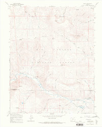
1967 Map of Jasper
USGS Topo · Published 1969About this map
The Rio Grande National Forest high country, straddling the boundary between Rio Grande and Conejos counties, is defined by its network of administrative outposts and high-altitude water sources. At the center of the sheet, the small settlement of Jasper sits along the winding course of the Alamosa River, served by a network of jeep and pack trails. This 1967 field-checked study records the logistical infrastructure of the mid-20th century forest service, including the Fitton Guard Station near Bennett Creek and the Alamosa Guard Station further downstream. The landscape is punctuated by prominent peaks like Bennett Peak and Cornwall Mountain, while the hydrology is dominated by alpine features such as the San Francisco Lakes and Silver Lakes. Local mining history is represented by the Miner label near Jasper Creek, while the livestock era is evident in the presence of several established stock driveways across the mountain passes.
Find a feature on this map
44 named features on this map. Tap any name to fly to it.
Don’t see what you’re looking for? This feature index may not catch every label — zoom into the map to look around manually.
Map Details
Editions of this 1967 Jasper Map
3 editions found
Other maps of this area

1913 · Summitville
USGS Topo · 1:125,000

1914 · Creede
USGS Topo · 1:125,000

1915 · Summitville
USGS Topo · 1:125,000

1915 · Del Norte
USGS Topo · 1:125,000

1916 · Creede
USGS Topo · 1:125,000

1917 · Del Norte
USGS Topo · 1:125,000

1922 · Conejos
USGS Topo · 1:125,000

1945 · Durango
USGS Topo · 1:250,000

1953 · Durango
USGS Topo · 1:250,000

1954 · Durango
USGS Topo · 1:250,000