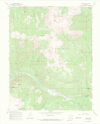
1967 Map of Jasper
USGS Topo · Published 1969About this map
The Rio Grande National Forest dominates this high-altitude landscape, where the Alamosa River cuts a deep path through the southern Rockies. Central to this 1960s survey is the settlement of Jasper, positioned along the riverbank near the confluence with Jasper Creek. The terrain is defined by prominent peaks including Bennett Peak, Silver Mountain, and the interestingly named Cornwalls Nose. A network of primitive transportation is evident through various Jeep Trails, Pack Trails, and Stock Driveways that crisscross the high ridges and gulches. Significant administrative outposts like the Fitton Guard Station and Alamosa Guard Station suggest the active management of these timber and grazing lands. Water resources are abundant, ranging from the high San Francisco Lakes to the drainage of California Gulch and Castleman Gulch, reflecting the complex hydrology of the Rio Grande and Conejos county borderlands.
Find a feature on this map
44 named features on this map. Tap any name to fly to it.
Don’t see what you’re looking for? This feature index may not catch every label — zoom into the map to look around manually.
Map Details
Editions of this 1967 Jasper Map
3 editions found
Other maps of this area

1913 · Summitville
USGS Topo · 1:125,000

1914 · Creede
USGS Topo · 1:125,000

1915 · Summitville
USGS Topo · 1:125,000

1915 · Del Norte
USGS Topo · 1:125,000

1916 · Creede
USGS Topo · 1:125,000

1917 · Del Norte
USGS Topo · 1:125,000

1922 · Conejos
USGS Topo · 1:125,000

1945 · Durango
USGS Topo · 1:250,000

1953 · Durango
USGS Topo · 1:250,000

1954 · Durango
USGS Topo · 1:250,000