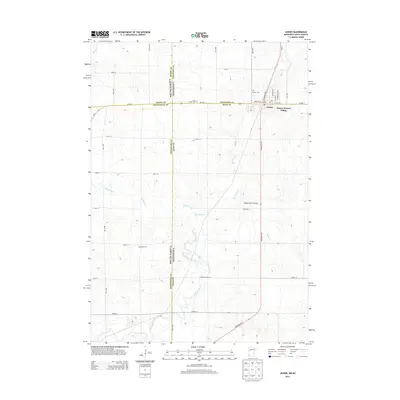
2013 Map of Jasper
USGS Topo · Published 2013About this map
Jasper sits at the intersection of four counties and two states, serving as a focal point for this agrarian landscape on the Coteau des Prairies plateau. The map details the precise boundary where South Dakota and Minnesota meet, specifically the juncture of Moody, Pipestone, Minnehaha, and Rock counties. The town center is organized around Wall St W, 1st St E, and the local Post Office, while Jasper Sunrise Village extends the settlement to the east. The surrounding countryside is defined by the winding paths of Split Rock Creek and Pipestone Cr. For those researching local heritage, the map identifies several burial grounds, including Saint Joseph Cem, Jasper Cem, and the more isolated Rosendal Cem situated near the state line. A network of rural roads, such as Township Road 72 and Co Hwy-14, connects these remote farmsteads and cemeteries.
Find a feature on this map
43 named features on this map. Tap any name to fly to it.
Don’t see what you’re looking for? This feature index may not catch every label — zoom into the map to look around manually.
Map Details
Editions of this 2013 Jasper Map
This is the sole edition of this map. No revisions or reprints were ever made.
Other maps of this area

1955 · Sioux Falls
USGS Topo · 1:250,000

1958 · Sioux Falls
USGS Topo · 1:250,000

1962 · Garretson West
USGS Topo · 1:24,000

1967 · Garretson East
USGS Topo · 1:24,000

1967 · Jasper SE
USGS Topo · 1:24,000

1967 · Hills NE
USGS Topo · 1:24,000

1967 · Pipestone South
USGS Topo · 1:24,000

1967 · Jasper
USGS Topo · 1:24,000

1967 · Jasper NW
USGS Topo · 1:24,000
1972 · Dell Rapids NE
USGS Topo · 1:24,000