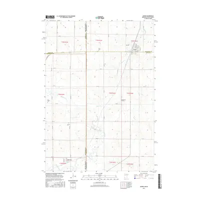
2016 Map of Jasper
USGS Topo · Published 2016About this map
Jasper and Sherman anchor this 2016 survey along the complex borderlands of Minnesota and South Dakota. The landscape is dominated by the Coteau des Prairies, a vast plateau that shapes the local hydrology, with Split Rock Creek and Pipestone Cr cutting through the agricultural grid. This modern record is particularly valuable for genealogists and local historians, as it meticulously preserves the locations of several regional burial grounds, including Jasper Cem, Saint Joseph Cem, Old Highland Cem, and Rosendal Cem. The map illustrates the persistent 19th-century township-and-range framework that continues to define property lines and road layouts across the county lines of Moody, Minnehaha, Pipestone, and Rock. A dense network of rural routes like Highland Rd and 241st St provides a clear view of the contemporary settlement pattern in this prairie region.
Find a feature on this map
58 named features on this map. Tap any name to fly to it.
Don’t see what you’re looking for? This feature index may not catch every label — zoom into the map to look around manually.
Map Details
Editions of this 2016 Jasper Map
This is the sole edition of this map. No revisions or reprints were ever made.
Other maps of this area

1955 · Sioux Falls
USGS Topo · 1:250,000

1958 · Sioux Falls
USGS Topo · 1:250,000

1962 · Garretson West
USGS Topo · 1:24,000

1967 · Garretson East
USGS Topo · 1:24,000

1967 · Jasper SE
USGS Topo · 1:24,000

1967 · Hills NE
USGS Topo · 1:24,000

1967 · Pipestone South
USGS Topo · 1:24,000

1967 · Jasper
USGS Topo · 1:24,000

1967 · Jasper NW
USGS Topo · 1:24,000
1972 · Dell Rapids NE
USGS Topo · 1:24,000