
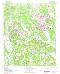
1949 Map of Jasper
USGS Topo · Published 1969About this map
Jasper serves as the industrial and transportation hub for Walker County on this mid-century survey, defined by its complex web of rail lines and early mining operations. The Southern and ST Louis San Francisco railroads converge in the town center, supporting the surrounding coal economy evidenced by the Strip Mine to the northwest and the Coke Oven near Coke Oven Hill. Residential pockets like Frisco Quarters and the developed area of Hillsdale show the growth of the community alongside public institutions like the Walker Co Hosp and Walker Co High Sch.
Find a feature on this map
70 named features on this map. Tap any name to fly to it.
Don’t see what you’re looking for? This feature index may not catch every label — zoom into the map to look around manually.
Map Details
Editions of this 1949 Jasper Map
2 editions found
Other maps of this area

1893 · Jasper
USGS Topo · 1:125,000

1935 · Port Birmingham
USGS Topo · 1:48,000

1938 · Port Birmingham
USGS Topo · 1:62,500

1949 · Cordova
USGS Topo · 1:24,000

1949 · Parrish
USGS Topo · 1:24,000

1949 · Townley
USGS Topo · 1:24,000

1949 · Oakman
USGS Topo · 1:24,000

1949 · Manchester
USGS Topo · 1:24,000

1949 · Nauvoo
USGS Topo · 1:24,000

1949 · Sunlight
USGS Topo · 1:24,000