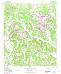
1949 Map of Jasper
USGS Topo · Published 1981About this map
Jasper serves as the industrial and civic heart of this Walker County landscape, reflecting a mid-century period of transition where traditional coal processing met post-war expansion. The presence of Coke Oven and Coke Oven Hill near the city center points to the area's deep ties to the regional mining economy, while the Walker County Airport and Walker Co Hosp indicate its role as a growing regional hub. Residential pockets like Frisco Quarters and outlying settlements such as McCollum and Hillsdale are linked by the Southern railway and the Bankhead Highway. Beyond the urban center, the terrain is defined by family-named landmarks and rural institutions, including Shoddy Chapel to the north and Grace Chapel near Stocks Hill. The drainage of Town Creek and Cane Creek provides a natural framework for the small communities and school sites like Slate Creek Sch that dot the countryside.
Find a feature on this map
62 named features on this map. Tap any name to fly to it.
Don’t see what you’re looking for? This feature index may not catch every label — zoom into the map to look around manually.
Map Details
Editions of this 1949 Jasper Map
2 editions found
Other maps of this area

1893 · Jasper
USGS Topo · 1:125,000

1935 · Port Birmingham
USGS Topo · 1:48,000

1938 · Port Birmingham
USGS Topo · 1:62,500

1949 · Cordova
USGS Topo · 1:24,000

1949 · Parrish
USGS Topo · 1:24,000

1949 · Townley
USGS Topo · 1:24,000

1949 · Jasper
USGS Topo · 1:24,000

1949 · Oakman
USGS Topo · 1:24,000

1949 · Manchester
USGS Topo · 1:24,000

1949 · Nauvoo
USGS Topo · 1:24,000