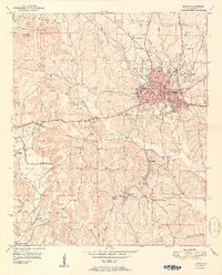
1951 Map of Jasper
USGS Topo · Published 1951About this map
Jasper serves as the bustling core of this mid-century Alabama landscape, where the confluence of the Southern and St. Louis San Francisco railroads highlights its importance as a regional transportation hub. The town is densely detailed, showing the Walker Co Hosp, City Hall, and the Walker Co High Sch during a period of significant post-war development. To the south and west, the terrain shifts into a complex network of ridges and hollows like Dark Hollow Branch and Horseshoe Mountain, interspersed with industrial markers such as a Strip Mine and the Coke Oven Hill. Numerous rural centers like McCollum and Sardis are visible, alongside foundational community landmarks including Snoddy Chapel and Grace Chapel. This survey effectively documents the intersection of Walker County's coal-driven economy and its established residential life before further modern expansion altered these smaller settlements.
Find a feature on this map
75 named features on this map. Tap any name to fly to it.
Don’t see what you’re looking for? This feature index may not catch every label — zoom into the map to look around manually.
Map Details
Editions of this 1951 Jasper Map
2 editions found

Other maps of this area

1893 · Jasper
USGS Topo · 1:125,000

1935 · Port Birmingham
USGS Topo · 1:48,000

1938 · Port Birmingham
USGS Topo · 1:62,500

1949 · Cordova
USGS Topo · 1:24,000

1949 · Parrish
USGS Topo · 1:24,000

1949 · Townley
USGS Topo · 1:24,000

1949 · Jasper
USGS Topo · 1:24,000

1949 · Oakman
USGS Topo · 1:24,000

1949 · Manchester
USGS Topo · 1:24,000

1949 · Nauvoo
USGS Topo · 1:24,000