
1951 Map of Jasper
USGS Topo · Published 1951About this map
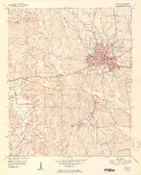
Jasper serves as the bustling hub of this 1951 survey, exhibiting the post-war expansion of the Walker County seat. The landscape is defined by its industrial roots, with strip mines dotting the terrain and the convergence of the Southern and Alabama Central RR lines. Distinctive neighborhoods and landmarks, such as Frisco Quarters and the Walker Co Hosp, are clearly visible, while the Walker County Airport anchors the northeastern edge of the settlement.
Find a feature on this map
59 named features on this map. Tap any name to fly to it.
Don’t see what you’re looking for? This feature index may not catch every label — zoom into the map to look around manually.
Map Details
Editions of this 1951 Jasper Map
2 editions found
Other maps of this area

1893 · Jasper
USGS Topo · 1:125,000

1935 · Port Birmingham
USGS Topo · 1:48,000

1938 · Port Birmingham
USGS Topo · 1:62,500

1949 · Cordova
USGS Topo · 1:24,000

1949 · Parrish
USGS Topo · 1:24,000

1949 · Townley
USGS Topo · 1:24,000

1949 · Jasper
USGS Topo · 1:24,000

1949 · Oakman
USGS Topo · 1:24,000

1949 · Manchester
USGS Topo · 1:24,000

1949 · Nauvoo
USGS Topo · 1:24,000