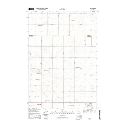
2015 Map of Java
USGS Topo · Published 2015About this map
Java anchors the southern portion of this high-plains landscape, where the town's grid meets the branching reaches of Hiddenwood Cr. This northern South Dakota terrain is defined by its deep genealogical roots, visible through a high concentration of rural burial grounds such as Bender Cem, Salzsiedler Cem, and Schnaible Cem. These scattered landmarks indicate the historical distribution of family farmsteads across the township lines. The northern section of the map straddles the boundary between Campbell Co and Walworth Co, reflecting the formal section-line road system that organizes the region's movement. Central to the area is the Hidden Wood Complex and Hiddenwood Lake, providing a distinct hydrological and recreational focal point amidst the undulating prairie contours.
Find a feature on this map
32 named features on this map. Tap any name to fly to it.
Don’t see what you’re looking for? This feature index may not catch every label — zoom into the map to look around manually.
Map Details
Editions of this 2015 Java Map
This is the sole edition of this map. No revisions or reprints were ever made.
Other maps of this area

1953 · McIntosh
USGS Topo · 1:250,000

1954 · Aberdeen
USGS Topo · 1:250,000

1956 · Aberdeen
USGS Topo · 1:250,000

1958 · McIntosh
USGS Topo · 1:250,000

1967 · Mound City
USGS Topo · 1:24,000

1967 · Selby
USGS Topo · 1:24,000

1968 · Akaska NE
USGS Topo · 1:24,000

1974 · Spring Lake
USGS Topo · 1:24,000
1974 · Lowry NW
USGS Topo · 1:24,000

1978 · Salt Lake
USGS Topo · 1:24,000