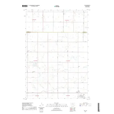
2017 Map of Java
USGS Topo · Published 2017About this map
Java serves as the primary hub of this landscape, situated along the southern edge of the survey area where Walworth County meets Campbell County. The town's grid is clearly defined by local landmarks like Chicago St and Helm St, providing a clear view of the settlement’s organization. Outside the town limits, the terrain is defined by the winding course of Hiddenwood Cr and the waters of Hiddenwood Lake. This rural stretch of the Great Plains is dotted with several family and community burial grounds, including the Bender Cem to the north and the Schnaible Cem further south. The presence of multiple denominational sites, such as the United Church of Java Reformed Cem and Congregational Cem, reflects the deep-rooted immigrant and community heritage that shaped this part of South Dakota.
Find a feature on this map
39 named features on this map. Tap any name to fly to it.
Don’t see what you’re looking for? This feature index may not catch every label — zoom into the map to look around manually.
Map Details
Editions of this 2017 Java Map
This is the sole edition of this map. No revisions or reprints were ever made.
Other maps of this area

1953 · McIntosh
USGS Topo · 1:250,000

1954 · Aberdeen
USGS Topo · 1:250,000

1956 · Aberdeen
USGS Topo · 1:250,000

1958 · McIntosh
USGS Topo · 1:250,000

1967 · Mound City
USGS Topo · 1:24,000

1967 · Selby
USGS Topo · 1:24,000

1968 · Akaska NE
USGS Topo · 1:24,000

1974 · Spring Lake
USGS Topo · 1:24,000
1974 · Lowry NW
USGS Topo · 1:24,000

1978 · Salt Lake
USGS Topo · 1:24,000