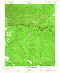
1947 Map of Jawbone Ridge
USGS Topo · Published 1963This historical map portrays the area of Jawbone Ridge in 1947, primarily covering Tuolumne County as well as portions of Mariposa County. Featuring a scale of 1:24000, this map provides a highly detailed snapshot of the terrain, roads, buildings, counties, and historical landmarks in the Jawbone Ridge region at the time. Published in 1963, it is one of 3 known editions of this map due to revisions or reprints.
Find a feature on this map
46 named features on this map. Tap any name to fly to it.
Don’t see what you’re looking for? This feature index may not catch every label — zoom into the map to look around manually.
Map Details
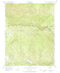
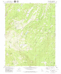
Editions of this 1947 Jawbone Ridge Map
3 editions found
Historical Maps of East Greeley Hill Through Time
91 maps found

1891 Big Trees
Tuolumne County, CA

1894 Big Trees
Tuolumne County, CA

1896 Dardanelles
Tuolumne County, CA

1897 Big Trees
Tuolumne County, CA

1898 Dardanelles
Tuolumne County, CA

1901 Big Trees
Tuolumne County, CA

1947 Jawbone Ridge
Tuolumne County, CA

1948 Columbia SE
Tuolumne County, CA

1948 Duckwall Mtn
Tuolumne County, CA

1948 Moccasin
Tuolumne County, CA

1948 Standard
Tuolumne County, CA

1948 Stanislaus
Tuolumne County, CA

1948 Tuolumne
Tuolumne County, CA

1948 Tuolumne
Tuolumne County, CA

1949 Columbia SE
Tuolumne County, CA

1949 Duckwall Mtn
Tuolumne County, CA

1949 Jawbone Ridge
Tuolumne County, CA

1949 Moccasin
Tuolumne County, CA

1949 Standard
Tuolumne County, CA

1949 Stanislaus
Tuolumne County, CA

1949 Tuolumne
Tuolumne County, CA

1956 Big Meadow
Tuolumne County, CA

1956 Dardanelles Cone
Tuolumne County, CA

1956 Hetch Hetchy Reservoir
Tuolumne County, CA

1956 Lake Eleanor
Tuolumne County, CA

1956 Pinecrest
Tuolumne County, CA

1956 Tower Peak
Tuolumne County, CA

1956 Tuolumne Meadows
Tuolumne County, CA

1962 Keystone
Tuolumne County, CA

1979 Boards Crossing
Tuolumne County, CA

1979 Cherry Lake North
Tuolumne County, CA

1979 Crandall Peak
Tuolumne County, CA

1979 Dardanelle
Tuolumne County, CA

1979 Donnell Lake
Tuolumne County, CA
1979 Hull Creek
Tuolumne County, CA

1979 Liberty Hill
Tuolumne County, CA

1979 Pinecrest
Tuolumne County, CA

1979 Sonora Pass
Tuolumne County, CA

1979 Strawberry
Tuolumne County, CA

1990 Ackerson Mountain
Tuolumne County, CA

1990 Ascension Mountain
Tuolumne County, CA

1990 Cherry Lake South
Tuolumne County, CA

1990 Cooper Peak
Tuolumne County, CA

1990 Emigrant Lake
Tuolumne County, CA

1990 Falls Ridge
Tuolumne County, CA

1990 Hetch Hetchy Reservoir
Tuolumne County, CA

1990 Kibbie Lake
Tuolumne County, CA

1990 Lake Eleanor
Tuolumne County, CA

1990 Matterhorn Peak
Tuolumne County, CA

1990 Piute Mountain
Tuolumne County, CA

1990 Tamarack Flat
Tuolumne County, CA

1990 Ten Lakes
Tuolumne County, CA

1990 Tiltill Mountain
Tuolumne County, CA

1990 Tioga Pass
Tuolumne County, CA

1990 Vogelsang Peak
Tuolumne County, CA

1992 Ackerson Mountain
Tuolumne County, CA

1992 Ascension Mountain
Tuolumne County, CA

1992 Cherry Lake South
Tuolumne County, CA

1992 Falls Ridge
Tuolumne County, CA

1992 Hetch Hetchy Reservoir
Tuolumne County, CA

1992 Lake Eleanor
Tuolumne County, CA

1992 Tamarack Flat
Tuolumne County, CA

1992 Ten Lakes
Tuolumne County, CA

1992 Tioga Pass
Tuolumne County, CA

1994 Tioga Pass
Tuolumne County, CA

1994 Vogelsang Peak
Tuolumne County, CA

1997 Tamarack Flat
Tuolumne County, CA

2000 Keystone
Tuolumne County, CA

2001 Ackerson Mountain
Tuolumne County, CA

2001 Ascension Mountain
Tuolumne County, CA

2001 Boards Crossing
Tuolumne County, CA

2001 Cherry Lake North
Tuolumne County, CA

2001 Cherry Lake South
Tuolumne County, CA

2001 Columbia SE
Tuolumne County, CA

2001 Cooper Peak
Tuolumne County, CA

2001 Crandall Peak
Tuolumne County, CA

2001 Dardanelle
Tuolumne County, CA

2001 Donnell Lake
Tuolumne County, CA

2001 Duckwall Mountain
Tuolumne County, CA

2001 Emigrant Lake
Tuolumne County, CA

2001 Hull Creek
Tuolumne County, CA

2001 Jawbone Ridge
Tuolumne County, CA

2001 Kibbie Lake
Tuolumne County, CA

2001 Lake Eleanor
Tuolumne County, CA

2001 Liberty Hill
Tuolumne County, CA

2001 Pinecrest
Tuolumne County, CA

2001 Sonora Pass
Tuolumne County, CA

2001 Stanislaus
Tuolumne County, CA

2001 Strawberry
Tuolumne County, CA

2001 Tiltill Mountain
Tuolumne County, CA

2001 Tuolumne
Tuolumne County, CA