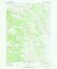
1968 Map of Jeff Cabin Creek
USGS Topo · Published 1973About this map
The Oregon Trail cuts across the northern reaches of the Portneuf Range in this late 1960s survey, marking a corridor of historical transit through the Idaho high country. This landscape is defined by the high-elevation divide between the Bannock and Caribou county lines, where the southern portion of the sheet is dominated by the Caribou National Forest. The map documents a complex system of drainage and movement, with numerous watercourses like Jeff Cabin Creek and Ross Creek feeding the larger basins.
Find a feature on this map
23 named features on this map. Tap any name to fly to it.
Don’t see what you’re looking for? This feature index may not catch every label — zoom into the map to look around manually.
Map Details
Editions of this 1968 Jeff Cabin Creek Map
2 editions found
Other maps of this area

1917 · Portneuf
USGS Topo · 1:62,500

1918 · Paradise Valley
USGS Topo · 1:62,500

1954 · Pocatello
USGS Topo · 1:250,000

1955 · Yandell Springs
USGS Topo · 1:62,500

1955 · Idaho Falls
USGS Topo · 1:250,000

1955 · Driggs
USGS Topo · 1:250,000

1955 · Preston
USGS Topo · 1:250,000

1958 · Driggs
USGS Topo · 1:250,000

1958 · Idaho Falls
USGS Topo · 1:250,000

1958 · Pocatello
USGS Topo · 1:250,000