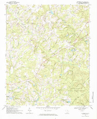
1968 Map of Jefferson NE
USGS Topo · Published 1984About this map
Black Creek and its many tributaries carve through the rolling terrain of Chesterfield County, defining a landscape of small-scale agriculture and timber in the late 1960s. The southeastern portion of the map is dominated by the Carolina Sandhills National Wildlife Refuge, where the Jumping Hills and Tan Trough indicate the distinct sandy topography of the region. This area shows a pattern of rural settlement anchored by numerous community landmarks, including Nicy Grove Ch and the Old Mt Olive Cem.
Find a feature on this map
66 named features on this map. Tap any name to fly to it.
Don’t see what you’re looking for? This feature index may not catch every label — zoom into the map to look around manually.
Map Details
Editions of this 1968 Jefferson NE Map
2 editions found

Other maps of this area

1941 · Spartanburg
USGS Topo · 1:250,000

1953 · Spartanburg
USGS Topo · 1:250,000

1960 · Spartanburg
USGS Topo · 1:250,000

1963 · Spartanburg
USGS Topo · 1:250,000

1964 · Spartanburg
USGS Topo · 1:250,000

1967 · Angelus
USGS Topo · 1:24,000

1967 · Mount Pisgah
USGS Topo · 1:24,000

1968 · Middendorf
USGS Topo · 1:24,000

1968 · Ruby
USGS Topo · 1:24,000

1968 · Jefferson
USGS Topo · 1:24,000