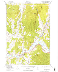
1948 Map of Jeffersonville
USGS Topo · Published 1976About this map
The Lamoille River valley serves as the central artery for this northern Vermont landscape, anchored by the settlement of Jeffersonville and the vital crossing at Cambridge Junction. Here, the St Johnsbury and Lamoille County rail line traces the river's path, connecting agricultural outposts like Waterville and East Fletcher. The map captures the region's topography just as aerial photography began to refine the mapping of the Green Mountains, showing the relationship between the rugged heights of Fletcher Mountain and the intervale farms below.
Find a feature on this map
42 named features on this map. Tap any name to fly to it.
Don’t see what you’re looking for? This feature index may not catch every label — zoom into the map to look around manually.
Map Details
Editions of this 1948 Jeffersonville Map
4 editions found
Other maps of this area

1919 · Montgomery
USGS Topo · 1:62,500

1920 · Franklin Pond
USGS Topo · 1:62,500

1920 · Montgomery
USGS Topo · 1:62,500

1922 · Enosburg Falls
USGS Topo · 1:48,000

1924 · Enosburg Falls
USGS Topo · 1:62,500

1925 · Jay Peak
USGS Topo · 1:62,500

1925 · Mount Mansfield
USGS Topo · 1:48,000

1927 · Mount Mansfield
USGS Topo · 1:62,500

1927 · Hyde Park
USGS Topo · 1:48,000

1930 · Hyde Park
USGS Topo · 1:62,500