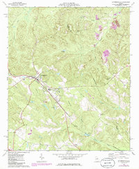
1974 Map of Jeffersonville
USGS Topo · Published 1985About this map
Jeffersonville serves as the focal point of this mid-1970s survey, showing the town at a time of established institutional growth with its County High Sch and Twiggs Jr High Sch. The landscape is characterized by its drainage network, with Turkey Creek and Alligator Creek winding through the terrain, while the Seaboard railroad line cuts a definitive path through the center of the county seat.
Find a feature on this map
33 named features on this map. Tap any name to fly to it.
Don’t see what you’re looking for? This feature index may not catch every label — zoom into the map to look around manually.
Map Details
Editions of this 1974 Jeffersonville Map
2 editions found
Other maps of this area

1916 · Irwinton
USGS Topo · 1:62,500

1920 · Irwinton
USGS Topo · 1:62,500

1956 · Gordon
USGS Topo · 1:62,500

1956 · Jeffersonville
USGS Topo · 1:62,500

1957 · Macon
USGS Topo · 1:250,000

1958 · Macon
USGS Topo · 1:250,000

1964 · Macon
USGS Topo · 1:250,000

1973 · Massey Hill
USGS Topo · 1:24,000
1973 · Irwinton
USGS Topo · 1:24,000

1973 · Tarversville
USGS Topo · 1:24,000