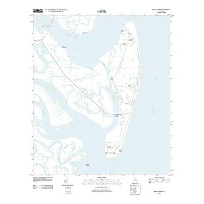
2011 Map of Jekyll Island
USGS Topo · Published 2011About this map
Jekyll Island dominates this coastal landscape, separated from the mainland by a complex network of salt marshes and tidal creeks. The island's development as a destination is evident through features like the Cherokee Campground, the Jekyll Island Airport, and the Jekyll Island Post Office. Local history is anchored at the DuBignon Cemetery, a reminder of the island's earlier plantation era. Transport to this barrier island is facilitated by the M E Thompson Memorial Bridge, while the massive Sidney Lanier Bridge spans the Brunswick River to the north, connecting the region. The interior is defined by winding water bodies like Jointer Creek and the Little Satilla River, while the eastern shore meets the Atlantic Ocean at Saint Andrew Beach. This map illustrates the intersection of modern recreation and historical land use along the Intracostal Waterway.
Find a feature on this map
37 named features on this map. Tap any name to fly to it.
Don’t see what you’re looking for? This feature index may not catch every label — zoom into the map to look around manually.
Map Details
Editions of this 2011 Jekyll Island Map
This is the sole edition of this map. No revisions or reprints were ever made.
Other maps of this area

1918 · Cumberland Island
USGS Topo · 1:62,500

1918 · Bladen
USGS Topo · 1:62,500

1918 · Kingsland
USGS Topo · 1:62,500

1930 · Cumberland Island
USGS Topo · 1:62,500

1939 · Bladen
USGS Topo · 1:62,500

1945 · Brunswick
USGS Topo · 1:62,500

1945 · Cumberland Island
USGS Topo · 1:62,500

1946 · Brunswick
USGS Topo · 1:250,000

1948 · Jacksonville
USGS Topo · 1:250,000

1948 · Brunswick
USGS Topo · 1:250,000