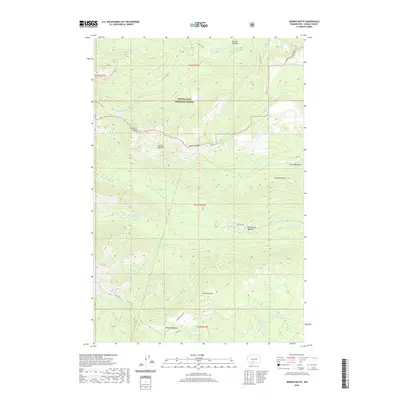
2020 Map of Jennies Butte
USGS Topo · Published 2020About this map
Snoqualmie National Forest dominates this section of the Cascade Range, defined by its high-altitude meadows and complex drainage systems. The landscape transitions from the headwaters of the S Fork Tieton River in the north to the Klickitat River in the central portion, revealing the hydrologic divide at Klickton Divide. Distinctive geographic features like Jennies Butte and Diamond Butte punctuate the topography, surrounded by a network of specialized habitats such as Huckleberry Swamp and Cedar Swamp. Historically, the area is marked by a series of significant clearings and meadows, including Conrad Meadows, McCormick Meadow, and Hussey Meadow, which suggest a legacy of high-country grazing or early forest management. Remote infrastructure is limited to specialized routes like Jennies Butte Rd and the Ten Day Trail, while Soda Spring indicates the presence of natural mineral outflows in the volcanic terrain.
Find a feature on this map
39 named features on this map. Tap any name to fly to it.
Don’t see what you’re looking for? This feature index may not catch every label — zoom into the map to look around manually.
Map Details
Editions of this 2020 Jennies Butte Map
This is the sole edition of this map. No revisions or reprints were ever made.
Other maps of this area

1902 · Mount Aix
USGS Topo · 1:125,000

1904 · Mt Aix
USGS Topo · 1:125,000

1904 · Mount Adams
USGS Topo · 1:125,000

1907 · Mount Adams
USGS Topo · 1:125,000

1950 · Yakima
USGS Topo · 1:250,000

1958 · Yakima
USGS Topo · 1:250,000

1961 · Yakima
USGS Topo · 1:250,000

1962 · White Pass
USGS Topo · 1:62,500

1967 · Darland Mtn
USGS Topo · 1:24,000
1969 · Castile Falls
USGS Topo · 1:24,000