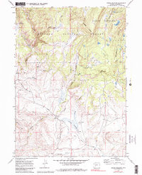
1969 Map of Jensen Meadows
USGS Topo · Published 1980About this map
Continental Divide winds through this high-country landscape, marking the hydrological crest of the Wind River Range during the late 1960s. The map highlights a significant historical corridor for western migration, featuring the intersecting paths of the Emigrant Trail, Lander Road, and the Lander Cutoff. These routes converge near Jensen Meadows and the Mitchell Slough, illustrating the primary thoroughfares used by travelers and livestock moving through the region. To the north, the Dutch Joe Guard Station stands as a lonely outpost of administrative presence within the Bridger National Forest. The terrain is defined by its complex water network, including the headwaters of Little Sandy Creek and Chicken Creek, alongside high-elevation features like Block and Tackle Hill and the protected lands of the Bridger Wilderness.
Find a feature on this map
26 named features on this map. Tap any name to fly to it.
Don’t see what you’re looking for? This feature index may not catch every label — zoom into the map to look around manually.
Map Details
Editions of this 1969 Jensen Meadows Map
2 editions found
Other maps of this area

1953 · Sweetwater Gap
USGS Topo · 1:24,000

1955 · Lander
USGS Topo · 1:250,000

1958 · Lander
USGS Topo · 1:250,000

1958 · Parting of the Ways
USGS Topo · 1:62,500

1961 · Lander
USGS Topo · 1:250,000

1969 · Leckie Reservoir
USGS Topo · 1:24,000

1969 · Jensen Meadows
USGS Topo · 1:24,000
1969 · Big Sandy Opening
USGS Topo · 1:24,000
1969 · Sweetwater Needles
USGS Topo · 1:24,000
1969 · Leckie
USGS Topo · 1:24,000