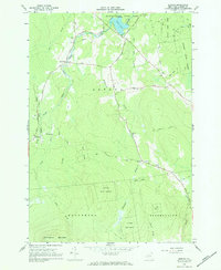
1966 Map of Jericho
USGS Topo · Published 1984About this map
Jericho and the surrounding Adirondack foothills are captured here in the mid-1960s, showing a landscape defined by state forestry and small, scattered settlements. To the north, Miner Lake State Park surrounds Miner Lake where the Chazy River flows toward the northeast. The map provides a detailed look at the local road network, including historic thoroughfares like Old Military Road and the Old Turnpike Road, which connect the small clusters of Alder Bend and Jerusalem.
Find a feature on this map
36 named features on this map. Tap any name to fly to it.
Don’t see what you’re looking for? This feature index may not catch every label — zoom into the map to look around manually.
Map Details
Editions of this 1966 Jericho Map
2 editions found
Other maps of this area

1895 · Mooers
USGS Topo · 1:62,500

1899 · Mooers
USGS Topo · 1:62,500

1911 · Lyon Mountain
USGS Topo · 1:62,500

1913 · Dannemora
USGS Topo · 1:62,500

1913 · Lyon Mountain
USGS Topo · 1:62,500

1915 · Churubusco
USGS Topo · 1:62,500

1931 · Lyon Mountain
USGS Topo · 1:62,500

1942 · Mooers
USGS Topo · 1:62,500

1943 · Churubusco
USGS Topo · 1:62,500

1943 · Mooers
USGS Topo · 1:62,500