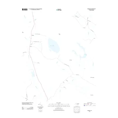
2013 Map of Jerome
USGS Topo · Published 2013About this map
Little Singletary Lake and Horseshoe Lake define the watery, low-lying character of this Bladen County landscape. The settlement of Jerome sits along the western edge of the quadrangle, connected to the surrounding countryside by a network of family-named roads like Dennis Harold Simmons Rd and Tatum and Monroe Ln. The terrain is marked by distinctive wetland features typical of the Carolina coastal plain, including several named "bays" such as Marshy Bay, Bucks Bay, and Thick Branch Bay. These oval-shaped depressions and sluggish watercourses like Lake Run and Harrison Cr create a complex hydrological pattern. Local heritage is further anchored by landmarks such as Live Oak Methodist Church Rd and Sharon Church Rd, which point to established rural community centers in a region historically dominated by timber and agriculture.
Find a feature on this map
35 named features on this map. Tap any name to fly to it.
Don’t see what you’re looking for? This feature index may not catch every label — zoom into the map to look around manually.
Map Details
Editions of this 2013 Jerome Map
This is the sole edition of this map. No revisions or reprints were ever made.
Other maps of this area

1953 · Florence
USGS Topo · 1:250,000

1954 · Florence
USGS Topo · 1:250,000

1955 · Elizabethtown
USGS Topo · 1:62,500

1957 · Bladenboro
USGS Topo · 1:62,500

1959 · Roseboro
USGS Topo · 1:62,500

1959 · Saint Pauls
USGS Topo · 1:62,500

1982 · Elizabethtown
USGS Topo · 1:100,000

1986 · Tar Heel
USGS Topo · 1:24,000
1986 · Duart
USGS Topo · 1:24,000
1986 · Cedar Creek
USGS Topo · 1:24,000