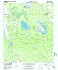
2002 Map of Jerome
USGS Topo · Published 2002About this map
The Carolina Bays landscape of Bladen and Cumberland Counties defines this area, characterized by the distinctive oval depressions of Bushy Lake and Little Singletary Lake. Much of the terrain is dedicated to conservation and managed wilderness, including the Bushy Lake State Natural Area and the Suggs Mill Pond State Game Land. These wetlands are interconnected by a network of drainage features like Ellis Creek and Turnbull Creek, while numerous smaller bays such as White Pond Bay, Big Gallberry Bay, and Marshy Bay create a complex mosaic of water and vegetation.
Find a feature on this map
43 named features on this map. Tap any name to fly to it.
Don’t see what you’re looking for? This feature index may not catch every label — zoom into the map to look around manually.
Map Details
Editions of this 2002 Jerome Map
This is the sole edition of this map. No revisions or reprints were ever made.
Other maps of this area

1953 · Florence
USGS Topo · 1:250,000

1954 · Florence
USGS Topo · 1:250,000

1955 · Elizabethtown
USGS Topo · 1:62,500

1957 · Bladenboro
USGS Topo · 1:62,500

1959 · Roseboro
USGS Topo · 1:62,500

1959 · Saint Pauls
USGS Topo · 1:62,500

1982 · Elizabethtown
USGS Topo · 1:100,000

1986 · Tar Heel
USGS Topo · 1:24,000
1986 · Duart
USGS Topo · 1:24,000
1986 · Cedar Creek
USGS Topo · 1:24,000