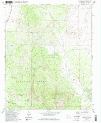
1979 Map of Jerome Canyon
USGS Topo · Published 1985About this map
Prescott National Forest dominates the southern reaches of this landscape, where the high peaks of Granite Mountain and Table Mtn overlook a series of canyons and seasonal washes. The historical footprint of early ranching and transit is visible at American Ranch (Site) and along the Atchison Topeka and Santa Fe railroad corridor. Numerous water sources, essential for survival in this arid environment, are mapped in detail, including Tin Trough Spring, Baker Spring, and Sheep Canyon Spring.
Find a feature on this map
30 named features on this map. Tap any name to fly to it.
Don’t see what you’re looking for? This feature index may not catch every label — zoom into the map to look around manually.
Map Details
Editions of this 1979 Jerome Canyon Map
2 editions found
Other maps of this area

1887 · Prescott
USGS Topo · 1:250,000

1892 · Prescott
USGS Topo · 1:250,000

1905 · Jerome
USGS Topo · 1:125,000

1947 · Simmons
USGS Topo · 1:62,500

1947 · Iron Springs
USGS Topo · 1:62,500

1947 · Paulden
USGS Topo · 1:62,500

1947 · Prescott
USGS Topo · 1:62,500

1948 · Iron Springs
USGS Topo · 1:63,360

1948 · Prescott
USGS Topo · 1:62,500

1948 · Simmons
USGS Topo · 1:63,360