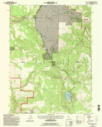
1993 Map of Jess Valley
USGS Topo · Published 1997About this map
Jess Valley forms the heart of this high-elevation landscape, where the Modoc National Forest meets the protected reaches of the Warner Mountains Wilderness. The map reveals a land defined by water management and ranching, evidenced by the extensive Ditch systems feeding into the valley and the presence of Blue Lake Ranch. Along the western edge of the valley floor, industrial activity is noted at the Modoc Peatmoss Co, indicating the local extraction of peat from the meadowlands. Elevations rise sharply toward the east onto Mahogany Ridge and the jagged peaks of the Warner Mountains. The survey also marks the remote settlement of Flourney and numerous family-named water sources like McKabe Creek and Parsnip Springs, providing a detailed look at the 1990s rural infrastructure in this corner of Modoc County.
Find a feature on this map
28 named features on this map. Tap any name to fly to it.
Don’t see what you’re looking for? This feature index may not catch every label — zoom into the map to look around manually.
Map Details
Editions of this 1993 Jess Valley Map
This is the sole edition of this map. No revisions or reprints were ever made.
Other maps of this area

1886 · Alturas
USGS Topo · 1:250,000

1892 · Alturas
USGS Topo · 1:250,000

1954 · Alturas
USGS Topo · 1:250,000

1958 · Alturas
USGS Topo · 1:250,000

1962 · Alturas
USGS Topo · 1:250,000

1962 · Tule Mountain
USGS Topo · 1:24,000
1962 · Madeline
USGS Topo · 1:24,000
1962 · Cold Spring Mtn
USGS Topo · 1:24,000

1962 · Jess Valley
USGS Topo · 1:24,000
1962 · Emerson Peak
USGS Topo · 1:24,000