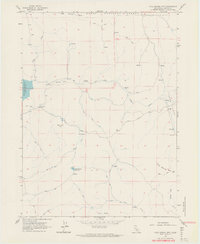
1962 Map of Cold Spring Mtn
USGS Topo · Published 1964About this map
Modoc National Forest spans the high terrain of northeastern California in this early 1960s survey, where the boundary between Modoc and Lassen counties intersects a landscape defined by seasonal water management and grazing infrastructure. The map reveals the intricate water network necessary for ranching in this arid region, featuring the Tule Lake Reservoir spillway and the Big Meadows Reservoir. Small-scale cattle operations are evidenced by landmarks like the Christensen Corral and Hall Cabin, which served as remote outposts along an extensive system of unimproved roads and jeep trails.
Find a feature on this map
29 named features on this map. Tap any name to fly to it.
Don’t see what you’re looking for? This feature index may not catch every label — zoom into the map to look around manually.
Map Details
Editions of this 1962 Cold Spring Mtn Map
4 editions found
Other maps of this area

1886 · Alturas
USGS Topo · 1:250,000

1886 · Honey Lake
USGS Topo · 1:250,000

1891 · Honey Lake
USGS Topo · 1:250,000

1892 · Alturas
USGS Topo · 1:250,000

1893 · Honey Lake
USGS Topo · 1:250,000

1954 · Observation Peak
USGS Topo · 1:62,500

1954 · Ravendale
USGS Topo · 1:62,500

1954 · Alturas
USGS Topo · 1:250,000

1955 · Westwood
USGS Topo · 1:250,000

1958 · Alturas
USGS Topo · 1:250,000