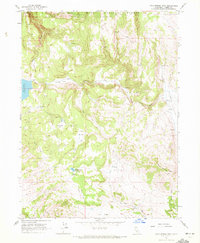
1962 Map of Cold Spring Mtn
USGS Topo · Published 1972About this map
Cold Spring Mtn anchors this high-elevation corner of the Modoc National Forest, where the boundary between Lassen and Modoc counties follows the ridgelines and watercourses. The 1962 field check captures a landscape defined by seasonal grazing and water management, illustrated by features like the Christensen Corral and Hall Cabin. Water is a central theme in this arid upland, with the Moon Lake spillway and the Big Meadows Reservoir providing essential storage.
Find a feature on this map
22 named features on this map. Tap any name to fly to it.
Don’t see what you’re looking for? This feature index may not catch every label — zoom into the map to look around manually.
Map Details
Editions of this 1962 Cold Spring Mtn Map
4 editions found
Other maps of this area

1886 · Alturas
USGS Topo · 1:250,000

1886 · Honey Lake
USGS Topo · 1:250,000

1891 · Honey Lake
USGS Topo · 1:250,000

1892 · Alturas
USGS Topo · 1:250,000

1893 · Honey Lake
USGS Topo · 1:250,000

1954 · Observation Peak
USGS Topo · 1:62,500

1954 · Ravendale
USGS Topo · 1:62,500

1954 · Alturas
USGS Topo · 1:250,000

1955 · Westwood
USGS Topo · 1:250,000

1958 · Alturas
USGS Topo · 1:250,000