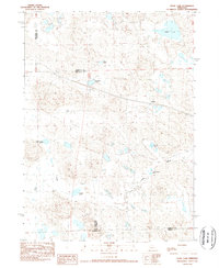
1989 Map of Jesse Lke
USGS Topo · Published 1989About this map
Hoffland sits at the heart of this Nebraska landscape, where the High Plains terrain is defined by an intricate network of ephemeral and semi-permanent water bodies. The settlement's proximity to Jesse Lake and the winding course of Snake Creek illustrates the importance of these water sources in the semi-arid Sandhills region. This 1989 provisional survey reveals a landscape largely shaped by its hydrology, showing numerous named basins such as Lee Sturgeon Lake, Clough Lake, and Sweeney Lake. The area spans several administrative boundaries, including the intersection of Sheridan, Box Butte, Morrill, and Garden counties. The mapping of Sewer Lake No 3 and O'Neil Lake further emphasizes the localized nature of these water features in a region where surface water dictates the patterns of ranching and land use.
Find a feature on this map
13 named features on this map. Tap any name to fly to it.
Don’t see what you’re looking for? This feature index may not catch every label — zoom into the map to look around manually.
Map Details
Editions of this 1989 Jesse Lke Map
This is the sole edition of this map. No revisions or reprints were ever made.
Other maps of this area

1896 · Browns Creek
USGS Topo · 1:125,000

1899 · Browns Creek
USGS Topo · 1:125,000

1946 · Berea Creek East
USGS Topo · 1:24,000

1947 · Alliance
USGS Topo · 1:24,000

1948 · Berea Creek East
USGS Topo · 1:24,000

1948 · Alliance
USGS Topo · 1:24,000

1948 · Antioch
USGS Topo · 1:62,500

1949 · Lynn
USGS Topo · 1:62,500

1949 · Antioch
USGS Topo · 1:62,500

1950 · Storm Lake
USGS Topo · 1:62,500