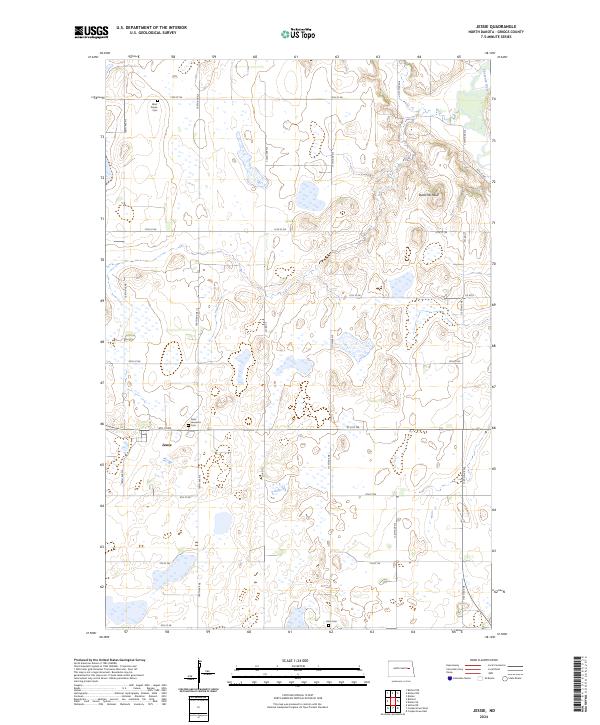
2024 Map of Jessie
USGS Topo · Published 2024About this map
The town of Jessie serves as the central hub of this North Dakota landscape, situated within a grid of section lines and agricultural roads typical of the Red River Valley hinterlands. Genealogical researchers will find localized landmarks such as Saint Lawrence Cem just north of town, along with West Prairie Cem and Hero Cem situated in the surrounding sections. The terrain is defined by its glacial heritage, featuring a complex network of wetlands and potholes that constitute the Griggs County Waterfowl Production Area. In the northeast corner, the Sheyenne River cuts across the boundary, while Butte Michaud rises as a distinct topographical marker in an otherwise gently undulating prairie. This layout illustrates a modern balance between small-town settlement and federal conservation efforts focused on the region's vital migratory habitats.
Find a feature on this map
29 named features on this map. Tap any name to fly to it.
Don’t see what you’re looking for? This feature index may not catch every label — zoom into the map to look around manually.
Map Details
Editions of this 2024 Jessie Map
This is the sole edition of this map. No revisions or reprints were ever made.
Other maps of this area

1952 · New Rockford
USGS Topo · 1:250,000

1956 · New Rockford
USGS Topo · 1:250,000

1961 · Kloten NW
USGS Topo · 1:24,000

1961 · Binford
USGS Topo · 1:24,000

1961 · Cooperstown East
USGS Topo · 1:24,000

1961 · Jessie
USGS Topo · 1:24,000

1961 · Binford NE
USGS Topo · 1:24,000

1961 · Cooperstown West
USGS Topo · 1:24,000

1961 · Sutton NE
USGS Topo · 1:24,000
1967 · Kloten SE
USGS Topo · 1:24,000