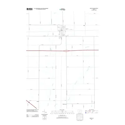
2013 Map of Jesup
USGS Topo · Published 2013About this map
Jesup serves as the primary hub in this portion of Buchanan County, centered on a dense grid of residential and commercial streets including Main St, Church St, and Prospect St. The surrounding landscape is defined by the headwaters and branches of Spring Cr and its eastern tributary, E Br Spring Cr, which meander through a heavily sectioned agricultural grid. The map details smaller rural clusters such as Shady Grove, Jubilee, and Wise, reflecting the dispersed nature of Iowa's farming communities in the early 21st century. High-capacity transportation corridors like Dubuque Rd and modern US highways intersect the traditional gravel road network, illustrating the evolution of rural transit. For researchers, this survey provides exact positioning of local landmarks and water bodies like Mud Cr in relation to family-named routes such as S Black Hawk Buchanan Ave.
Find a feature on this map
69 named features on this map. Tap any name to fly to it.
Don’t see what you’re looking for? This feature index may not catch every label — zoom into the map to look around manually.
Map Details
Editions of this 2013 Jesup Map
This is the sole edition of this map. No revisions or reprints were ever made.
Other maps of this area

1901 · Oelwein
USGS Topo · 1:125,000

1903 · Winthrop
USGS Topo · 1:125,000

1954 · Waterloo
USGS Topo · 1:250,000

1955 · Waterloo
USGS Topo · 1:250,000

1959 · Dubuque
USGS Topo · 1:250,000

1961 · Dubuque
USGS Topo · 1:250,000

1962 · Dubuque
USGS Topo · 1:250,000

1971 · Gilbertville
USGS Topo · 1:24,000

1971 · La Porte City
USGS Topo · 1:24,000
1971 · Brandon
USGS Topo · 1:24,000