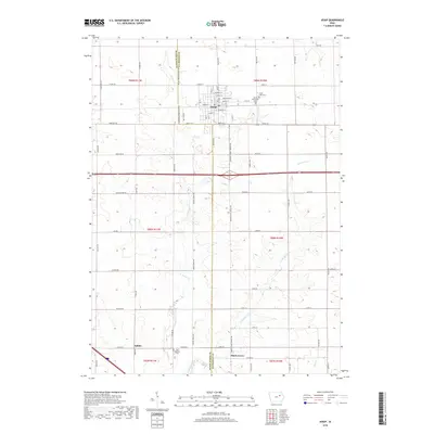
2018 Map of Jesup
USGS Topo · Published 2018About this map
Jesup serves as the primary municipal center in this 2018 survey, positioned along the border between Black Hawk and Buchanan Counties. The landscape is defined by the agricultural grid of Iowa's heartland, punctuated by small community hubs like Jubilee and Shady Grove. Family and local history are anchored by several religious and commemorative sites, including Cedar Crest Cem and Saint Athanasius Cem in the north, while the Zion Lutheran Cem marks the southern rural reaches near Jubilee Rd. Drainage patterns for these fertile fields are dictated by the meandering paths of Spring Cr and the East Branch Spring Creek, which cut through the township sections. This modern topographic record captures the enduring intersection of rural townships and the small-town infrastructure that supports the region's farming heritage.
Find a feature on this map
74 named features on this map. Tap any name to fly to it.
Don’t see what you’re looking for? This feature index may not catch every label — zoom into the map to look around manually.
Map Details
Editions of this 2018 Jesup Map
This is the sole edition of this map. No revisions or reprints were ever made.
Other maps of this area

1901 · Oelwein
USGS Topo · 1:125,000

1903 · Winthrop
USGS Topo · 1:125,000

1954 · Waterloo
USGS Topo · 1:250,000

1955 · Waterloo
USGS Topo · 1:250,000

1959 · Dubuque
USGS Topo · 1:250,000

1961 · Dubuque
USGS Topo · 1:250,000

1962 · Dubuque
USGS Topo · 1:250,000

1971 · Gilbertville
USGS Topo · 1:24,000

1971 · La Porte City
USGS Topo · 1:24,000
1971 · Brandon
USGS Topo · 1:24,000