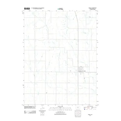
2012 Map of Jewell
USGS Topo · Published 2012About this map
Jewell serves as the central hub of this agricultural landscape in northern Kansas, where the community is defined by a grid of streets including Broadway St and Amity St. The local economy and settlement patterns are dictated by an intricate network of waterways, primarily the various branches of Buffalo Creek. W Buffalo Cr, Middle Buffalo Cr, and E Buffalo Cr flow southward through the section lines, converging near the town center. For those researching local lineages, the map identifies several burial grounds that mark the heritage of the area, including Jewell Cem just west of the town site, Union Cem to the southwest, and E Buffalo Cem located along the eastern reaches of the creek system. The surrounding rural landscape is strictly organized by a network of section roads like Sand Rd and H Rd, illustrating the enduring influence of the Public Land Survey System on Kansas farming.
Find a feature on this map
19 named features on this map. Tap any name to fly to it.
Don’t see what you’re looking for? This feature index may not catch every label — zoom into the map to look around manually.
Map Details
Editions of this 2012 Jewell Map
This is the sole edition of this map. No revisions or reprints were ever made.
Other maps of this area

1894 · Mankato
USGS Topo · 1:125,000

1955 · Beloit
USGS Topo · 1:250,000

1959 · Beloit
USGS Topo · 1:250,000

1962 · Jewell SE
USGS Topo · 1:24,000

1962 · Glen Elder North
USGS Topo · 1:24,000

1962 · Jewell SW
USGS Topo · 1:24,000

1968 · Burr Oak
USGS Topo · 1:24,000
1969 · Randall
USGS Topo · 1:24,000
1969 · Ionia
USGS Topo · 1:24,000

1969 · Mankato
USGS Topo · 1:24,000