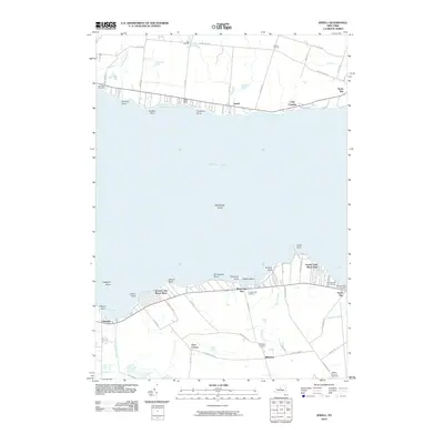
2010 Map of Jewell
USGS Topo · Published 2010About this map
Oneida Lake dominates this northern Madison County landscape, its southern and northern shorelines dotted with seasonal and year-round settlements. To the north, the small community of Jewell sits between Eaton Bay and Hall Brook, while the southern shore is defined by recreational developments like Oneida Lake Beach West and Oneida Lake Beach East. This 2010 survey illustrates a shoreline long-shaped by tourism and lakeside living, highlighted by the Pier Number 31 Marina near South Bay. Inland, the terrain transitions to agricultural use around Whitelaw and Gees Corner, where drainage networks like Mead Creek and Stephens Creek feed back into the lake system. Local history is anchored by several sites including Oneida Lake Cemetery and Lakewood Cemetery, which serve as quiet markers of the area's established rural hamlets like Hall Corners and Loomis Corners.
Find a feature on this map
70 named features on this map. Tap any name to fly to it.
Don’t see what you’re looking for? This feature index may not catch every label — zoom into the map to look around manually.
Map Details
Editions of this 2010 Jewell Map
This is the sole edition of this map. No revisions or reprints were ever made.
Other maps of this area

1895 · Chittenango
USGS Topo · 1:62,500

1895 · Oneida
USGS Topo · 1:62,500

1898 · Oneida
USGS Topo · 1:62,500

1898 · Chittenango
USGS Topo · 1:62,500

1902 · Chittenango
USGS Topo · 1:62,500

1902 · Oneida
USGS Topo · 1:62,500

1905 · Taberg
USGS Topo · 1:62,500

1906 · Kasoag
USGS Topo · 1:62,500

1939 · Oneida
USGS Topo · 1:62,500

1941 · Cleveland
USGS Topo · 1:24,000