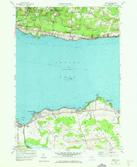
1957 Map of Jewell
USGS Topo · Published 1973About this map
Oneida Lake dominates this mid-century landscape, serving as a focal point for the lakeside communities of Cleveland, Jewell, and Lakeport. The map captures a period when the shoreline was heavily utilized for recreation and transit, featuring a Seaplane Base near Gifford Point and a Boat Launching Site at Godfrey Point. Inland, the agricultural and rural character of Madison Co and Oneida Co is evident through family-named junctions like Gees Corner and Loomis Corners, alongside social centers like the Oneida Lake Ch and Lakeport Chapel. The Erie Canal cuts through the center of the lake, while the southern marshlands are drained by the Douglas Ditch and Canaseraga Creek. This survey reveals the fine-grained geography of the shore, from the hazards of Messenger Shoal to the small settlements at Long Crossing and Oneida Lake Beach West.
Find a feature on this map
46 named features on this map. Tap any name to fly to it.
Don’t see what you’re looking for? This feature index may not catch every label — zoom into the map to look around manually.
Map Details
Editions of this 1957 Jewell Map
Other maps of this area

1895 · Chittenango
USGS Topo · 1:62,500

1895 · Oneida
USGS Topo · 1:62,500

1898 · Oneida
USGS Topo · 1:62,500

1898 · Chittenango
USGS Topo · 1:62,500

1902 · Chittenango
USGS Topo · 1:62,500

1902 · Oneida
USGS Topo · 1:62,500

1905 · Taberg
USGS Topo · 1:62,500

1906 · Kasoag
USGS Topo · 1:62,500

1939 · Oneida
USGS Topo · 1:62,500

1941 · Cleveland
USGS Topo · 1:24,000