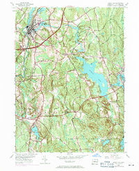
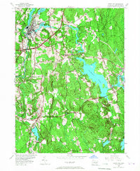
1953 Map of Jewett City
USGS Topo · Published 1971About this map
Jewett City sits at the confluence of the Quinebaug River and Pachaug River, anchoring a landscape defined by its industrial waterpower history. Small mill settlements such as Clayville, Ashland, and Glasgo are distributed along the waterways, each tied to its respective pond. The map reveals the post-war modernization of eastern Connecticut, with the Connecticut Turnpike cutting through the terrain and the Penn Central rail line following the river valley. Significant portions of the eastern half are dedicated to public lands, notably the Pachaug State Forest and Hopeville Pond State Park. This 1953 survey, updated with 1970 revisions, documents a transitional era where traditional manufacturing hamlets coexisted with new high-speed transit corridors. Local institutions, including the Bethel Ch, Glasgo Sch, and the Pachaug Cem, provide essential anchor points for genealogical and community history research in Griswold and Voluntown.
Find a feature on this map
59 named features on this map. Tap any name to fly to it.
Don’t see what you’re looking for? This feature index may not catch every label — zoom into the map to look around manually.
Map Details
Editions of this 1953 Jewett City Map
5 editions found
Other maps of this area

1889 · Stonington
USGS Topo · 1:62,500

1889 · Moosup
USGS Topo · 1:62,500

1892 · New London
USGS Topo · 1:62,500

1892 · Norwich
USGS Topo · 1:62,500

1893 · Moosup
USGS Topo · 1:62,500

1893 · Stonington
USGS Topo · 1:62,500

1893 · New London
USGS Topo · 1:62,500

1920 · Moosup
USGS Topo · 1:62,500

1921 · New London
USGS Topo · 1:62,500

1921 · Stonington
USGS Topo · 1:62,500