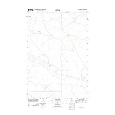
2011 Map of Jim Coulee
USGS Topo · Published 2011About this map
Jim Coulee carves through this arid stretch of Musselshell County, defining a landscape of intermittent drainages and essential water management features. The area's reliance on seasonal water sources is evident in the presence of Little Wall Dam and Willow Dam, which capture runoff in a region dominated by the winding paths of Little Wall Creek and North Willow Creek. These small-scale water works are vital landmarks in a sparsely populated ranching environment where N Gage Rd serves as the primary north-south artery. The drainage network is further detailed by the courses of Howard Creek in the northeast and Crooked Creek in the southwest, illustrating the subtle topographic shifts that dictate the movement of water across this high-plains terrain during the early 21st century.
Find a feature on this map
8 named features on this map. Tap any name to fly to it.
Don’t see what you’re looking for? This feature index may not catch every label — zoom into the map to look around manually.
Map Details
Editions of this 2011 Jim Coulee Map
This is the sole edition of this map. No revisions or reprints were ever made.
Other maps of this area

1954 · Roundup
USGS Topo · 1:250,000

1958 · Roundup
USGS Topo · 1:250,000

1963 · Kelley
USGS Topo · 1:24,000

1963 · Musselshell NW
USGS Topo · 1:24,000

1963 · Delphia
USGS Topo · 1:24,000

1986 · Flatwillow
USGS Topo · 1:24,000

1986 · Crowley Dam
USGS Topo · 1:24,000

1986 · Big Wall West
USGS Topo · 1:24,000

1986 · Big Wall NW
USGS Topo · 1:24,000
1986 · Big Wall East
USGS Topo · 1:24,000