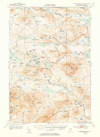
1952 Map of Jo-Mary Mountain
USGS Topo · Published 1953About this map
Jo-Mary Mountain and the surrounding wilderness of Piscataquis County are defined by a dense concentration of high peaks and interconnected glacial lakes. In the early 1950s, this landscape remained largely defined by traditional backcountry uses, featuring prominent fire detection infrastructure such as the Wadleigh Lookout Tower and White Cap Mtn Lookout Tower. The Appalachian Trail threads through the topography, connecting the slopes of Nasuntabunt Mountain and White Cap Mountain. This area is characterized by its complex hydrology, where bodies of water like Nahmakanta Lake and Lower Jo-Mary Lake are separated by significant landforms like Potaywadjo Ridge. The survey meticulously documents the township boundaries, including T 1 R 11 and T B R 10, illustrating the formal administrative grid imposed upon this remote timberland and mountain terrain.
Find a feature on this map
108 named features on this map. Tap any name to fly to it.
Don’t see what you’re looking for? This feature index may not catch every label — zoom into the map to look around manually.
Map Details
Editions of this 1952 Jo-Mary Mountain Map
5 editions found

Other maps of this area

1927 · Katahdin
USGS Topo · 1:48,000

1930 · Katahdin
USGS Topo · 1:62,500

1940 · Sebec
USGS Topo · 1:48,000

1943 · Sebec
USGS Topo · 1:62,500

1947 · Schoodic
USGS Topo · 1:62,500

1949 · Schoodic
USGS Topo · 1:62,500

1949 · Katahdin
USGS Topo · 1:62,500

1950 · Sebec Lake
USGS Topo · 1:62,500

1951 · Norcross
USGS Topo · 1:62,500

1952 · Jo-Mary Mountain
USGS Topo · 1:62,500