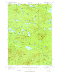
1952 Map of Jo-Mary Mountain
USGS Topo · Published 1964About this map
Appalachian Trail trekkers in the early 1950s encountered a landscape defined by expansive water bodies and high-elevation surveillance points. This interior section of Maine is anchored by the massive Nahamakanta Lake and the complex of Penobscot Pond and Henderson Pond, surrounded by ridges like Potaywadjo Ridge and Turtle Ridge. The region's network of lookouts, including the Wadleigh Mountain Lookout Tower and White Cap Mtn Lookout Tower, highlights the era's reliance on stationary fire observation across these timbered townships. Notable hydrological features such as Gauntlet Falls and the distinctively named Mud Gauntlet Falls mark the descent of the region's many brooks and streams. The map documents an area transition from raw wilderness to managed forest, indicated by several routes labeled Private, suggesting the early infrastructure of the commercial logging industry that would eventually shape much of the Piscataquis interior.
Find a feature on this map
121 named features on this map. Tap any name to fly to it.
Don’t see what you’re looking for? This feature index may not catch every label — zoom into the map to look around manually.
Map Details
Editions of this 1952 Jo-Mary Mountain Map
5 editions found

Other maps of this area

1927 · Katahdin
USGS Topo · 1:48,000

1930 · Katahdin
USGS Topo · 1:62,500

1940 · Sebec
USGS Topo · 1:48,000

1943 · Sebec
USGS Topo · 1:62,500

1947 · Schoodic
USGS Topo · 1:62,500

1949 · Schoodic
USGS Topo · 1:62,500

1949 · Katahdin
USGS Topo · 1:62,500

1950 · Sebec Lake
USGS Topo · 1:62,500

1951 · Norcross
USGS Topo · 1:62,500

1952 · Jo-Mary Mountain
USGS Topo · 1:62,500