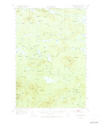
1952 Map of Jo-Mary Mountain
USGS Topo · Published 1973About this map
The Appalachian Trail winds through this mid-century landscape, crossing a complex network of glacial lakes and mountain ridges in Piscataquis County. This 1952 field-checked survey reveals a wilderness managed for timber and recreation, with a prominent Lookout Tower standing atop Wadleigh Mountain. The map detail follows the trail as it skirts Nahamakanta Lake and crosses Potaywadjo Ridge, providing a clear look at the topographic character of the region before modern development patterns.
Find a feature on this map
114 named features on this map. Tap any name to fly to it.
Don’t see what you’re looking for? This feature index may not catch every label — zoom into the map to look around manually.
Map Details
Editions of this 1952 Jo-Mary Mountain Map
5 editions found

Other maps of this area

1927 · Katahdin
USGS Topo · 1:48,000

1930 · Katahdin
USGS Topo · 1:62,500

1940 · Sebec
USGS Topo · 1:48,000

1943 · Sebec
USGS Topo · 1:62,500

1947 · Schoodic
USGS Topo · 1:62,500

1949 · Schoodic
USGS Topo · 1:62,500

1949 · Katahdin
USGS Topo · 1:62,500

1950 · Sebec Lake
USGS Topo · 1:62,500

1951 · Norcross
USGS Topo · 1:62,500

1952 · Jo-Mary Mountain
USGS Topo · 1:62,500