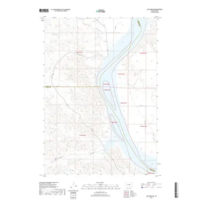
2017 Map of Joe Creek NW
USGS Topo · Published 2017About this map
Lake Sharpe dominates the Missouri River valley where the borders of Hughes, Stanley, and Lyman counties converge. This 2017 study illustrates the complex riparian landscape of the Big Bend District, where the main channel of the Missouri River is fed by numerous drainages including LaRoche Cr, First Cr, and Julius Cr. The upland terrain is marked by a network of rural roads such as Cedar Creek Rd and Co Hwy 21, which serve the sparsely populated ranching and agricultural lands of central South Dakota. A significant point of local interest is the Holy Faith Cem, located in the southwest corner of the map near the S Fork Cedar Cr. This intersection of water and land highlights the importance of the river system to the region's geography and the enduring presence of local landmarks in a vast, open landscape.
Find a feature on this map
24 named features on this map. Tap any name to fly to it.
Don’t see what you’re looking for? This feature index may not catch every label — zoom into the map to look around manually.
Map Details
Editions of this 2017 Joe Creek NW Map
This is the sole edition of this map. No revisions or reprints were ever made.
Other maps of this area

1934 · Canning
USGS Topo · 1:48,000

1937 · Canning
USGS Topo · 1:62,500

1953 · Huron
USGS Topo · 1:250,000

1954 · Pierre
USGS Topo · 1:250,000

1954 · Huron
USGS Topo · 1:250,000

1958 · Pierre
USGS Topo · 1:250,000

1966 · Joe Creek
USGS Topo · 1:24,000

1966 · Ft. George Butte SE
USGS Topo · 1:24,000

1966 · Joe Creek NW
USGS Topo · 1:24,000

1966 · Joe Creek SE
USGS Topo · 1:24,000