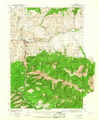
1940 Map of John Day
USGS Topo · Published 1967About this map
Canyon City and the neighboring settlement of John Day anchor this 1940 survey of the upper John Day River valley, a region defined by its gold mining history and rugged timberlands. The landscape is marked by the extensive Humboldt Diggings and numerous lode mines throughout the surrounding heights, including the Potato Patch Mine and the Golden West Mine (abandoned). This era shows the community at a crossroads of resource extraction and early conservation, with the Malheur National Forest and the Canyon Creek Game Refuge occupying the southern half of the quadrangle. Outside the towns, the map records a network of family-owned ranching operations such as the Trowbridge Ranch and Oliver Ranch, alongside rural education centers like Marysville School and Indian Creek School. Infrastructure of the day is noted by the Emergency Landing Field and the development of Highway 26.
Find a feature on this map
81 named features on this map. Tap any name to fly to it.
Don’t see what you’re looking for? This feature index may not catch every label — zoom into the map to look around manually.
Map Details
Editions of this 1940 John Day Map
2 editions found
Other maps of this area

1940 · Mount Vernon
USGS Topo · 1:62,500

1940 · John Day
USGS Topo · 1:62,500

1943 · John Day
USGS Topo · 1:62,500

1943 · Mount Vernon
USGS Topo · 1:62,500

1949 · Long Creek
USGS Topo · 1:62,500

1949 · Susanville
USGS Topo · 1:62,500

1951 · Susanville
USGS Topo · 1:62,500

1951 · Long Creek
USGS Topo · 1:62,500

1951 · Bates
USGS Topo · 1:62,500

1955 · Canyon City
USGS Topo · 1:250,000