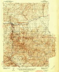
1943 Map of John Day
USGS Topo · Published 1943About this map
Canyon City and the neighboring town of John Day serve as the primary hubs in this central Oregon landscape, where the John Day River flows through a valley defined by the high elevations of the Malheur National Forest. The 1943 survey documents a region deeply shaped by its extractive history, as evidenced by a concentration of gold-era sites like the Old Humboldt Diggings and Prairie Diggings. Many operations such as the Great Northwestern Mine and Celebration Mine were already marked as inactive by the time of publication, reflecting a transition toward the ranching economy seen in the numerous family-held properties like Trowbridge Ranch and Kuhl Ranch. Local recreation and conservation are represented by the Joaquin Miller Resort and the Canyon Creek Game Refuge, while the Emergency Landing Field west of town highlights the era's growing aviation infrastructure.
Find a feature on this map
83 named features on this map. Tap any name to fly to it.
Don’t see what you’re looking for? This feature index may not catch every label — zoom into the map to look around manually.
Map Details
Editions of this 1943 John Day Map
2 editions found
Other maps of this area

1940 · Mount Vernon
USGS Topo · 1:62,500

1940 · John Day
USGS Topo · 1:62,500

1943 · John Day
USGS Topo · 1:62,500

1943 · Mount Vernon
USGS Topo · 1:62,500

1949 · Long Creek
USGS Topo · 1:62,500

1949 · Susanville
USGS Topo · 1:62,500

1951 · Susanville
USGS Topo · 1:62,500

1951 · Long Creek
USGS Topo · 1:62,500

1951 · Bates
USGS Topo · 1:62,500

1955 · Canyon City
USGS Topo · 1:250,000