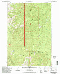
1995 Map of John Day Mountain
USGS Topo · Published 1999About this map
Nez Perce National Forest dominates this Idaho landscape, characterized by the high elevations of John Day Mountain and the prominent Brushy Ridge. This 1990s-era topographical survey, based on photogrammetry from earlier decades, illustrates a highly dissected terrain defined by the drainages of the East Fork John Day Creek and South Fork John Day Creek. The map records a wilderness managed for both conservation and public access, featuring the high-altitude Nut Basin Lake and the Nut Basin Viewpoint.
Find a feature on this map
28 named features on this map. Tap any name to fly to it.
Don’t see what you’re looking for? This feature index may not catch every label — zoom into the map to look around manually.
Map Details
Editions of this 1995 John Day Mountain Map
This is the sole edition of this map. No revisions or reprints were ever made.
Other maps of this area

1938 · Riggins
USGS Topo · 1:96,000

1945 · Riggins
USGS Topo · 1:125,000

1955 · Grangeville
USGS Topo · 1:250,000

1959 · Grangeville
USGS Topo · 1:250,000

1963 · John Day Mtn
USGS Topo · 1:24,000

1963 · Lucile
USGS Topo · 1:24,000

1963 · McKinzie Creek
USGS Topo · 1:24,000

1963 · Slate Creek
USGS Topo · 1:24,000
1963 · Dairy Mountain
USGS Topo · 1:24,000
1963 · Florence
USGS Topo · 1:24,000