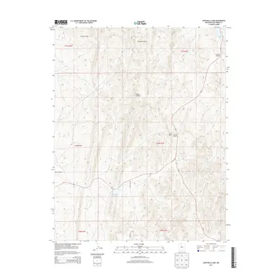
2013 Map of John Mills Lake
USGS Topo · Published 2013About this map
Bixler Ranch stands as a point of human settlement in this high-elevation landscape of Rio Arriba County. The terrain is defined by deep drainages such as Carracas Canyon and Martinez Canyon, which cut through the uplifted plateaus. Water management is central to the area's geography, visible in the namesake John Mills Lake and the smaller Dulce Lake tucked into the northeastern corner. Transportation through these elevations relies on routes like NM-537 and the descriptive Pounds Mill Rd, which navigate the rises near Burns Hill. Other landmarks like Piedra Agujero and Piedra Spring indicate the geologic and hydrological features that have likely supported local ranching and transit through the Dulce Canyon area for generations.
Find a feature on this map
19 named features on this map. Tap any name to fly to it.
Don’t see what you’re looking for? This feature index may not catch every label — zoom into the map to look around manually.
Map Details
Editions of this 2013 John Mills Lake Map
This is the sole edition of this map. No revisions or reprints were ever made.
Other maps of this area

1889 · Largo
USGS Topo · 1:250,000

1895 · Largo
USGS Topo · 1:250,000

1954 · Aztec
USGS Topo · 1:250,000

1955 · Lumberton
USGS Topo · 1:62,500

1955 · Boulder Lake
USGS Topo · 1:62,500

1958 · Aztec
USGS Topo · 1:250,000

1962 · Aztec
USGS Topo · 1:250,000
1963 · Cement Lake
USGS Topo · 1:24,000
1963 · John Mills Lake
USGS Topo · 1:24,000
1963 · Wirt Canyon
USGS Topo · 1:24,000