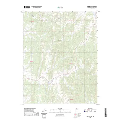
2023 Map of John Mills Lake
USGS Topo · Published 2023About this map
John Mills Lake and the northern Dulce Lake anchor this modern-day topographic perspective of the high-elevation landscape in Rio Arriba County. The terrain is defined by a dense network of drainages and named ridges, including the deep cuts of Martinez Canyon and Carracas Canyon. This 2023 survey provides a clear view of how rural infrastructure navigates this complex topography, with Pounds Mill Rd and Paiz St following the contours of the land. Local landmarks like Burns Hill and the prominent Piedra Agujero rise above the series of canyons, such as Burns Canyon and Cordova Canyon, that drain the surrounding highlands.
Find a feature on this map
17 named features on this map. Tap any name to fly to it.
Don’t see what you’re looking for? This feature index may not catch every label — zoom into the map to look around manually.
Map Details
Editions of this 2023 John Mills Lake Map
This is the sole edition of this map. No revisions or reprints were ever made.
Other maps of this area

1889 · Largo
USGS Topo · 1:250,000

1895 · Largo
USGS Topo · 1:250,000

1954 · Aztec
USGS Topo · 1:250,000

1955 · Lumberton
USGS Topo · 1:62,500

1955 · Boulder Lake
USGS Topo · 1:62,500

1958 · Aztec
USGS Topo · 1:250,000

1962 · Aztec
USGS Topo · 1:250,000
1963 · Cement Lake
USGS Topo · 1:24,000
1963 · John Mills Lake
USGS Topo · 1:24,000
1963 · Wirt Canyon
USGS Topo · 1:24,000