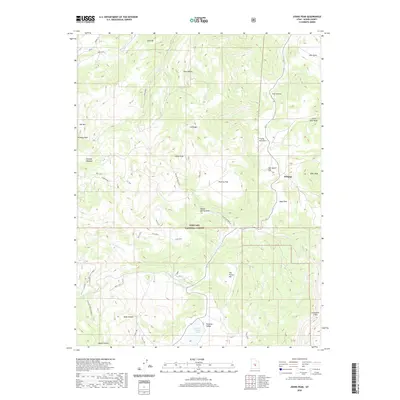
2020 Map of Johns Peak
USGS Topo · Published 2020About this map
Johns Peak and Kinneys Peak anchor this high-elevation landscape within the Fishlake National Forest, where steep ridges and deep hollows define the drainage patterns of Red Creek and Clear Creek. The terrain is marked by a complex network of forest trails, including Trail 2270 and the Gwt Alt (Tidwell Slopes), which navigate the transitions between open flats like Poverty Flat and secluded pockets such as Sage Hole. At the turn of the 21st century, the area remained largely undeveloped, with Jims Farm in the northeast corner standing as a rare named site of human activity. The map reveals the hydrology of the High Plateaus, tracing how Round Spring and Paradise Valley Lake feed into various forks of Last Chance Creek, illustrating a landscape shaped by seasonal water flow and high-altitude grazing land.
Find a feature on this map
46 named features on this map. Tap any name to fly to it.
Don’t see what you’re looking for? This feature index may not catch every label — zoom into the map to look around manually.
Map Details
Editions of this 2020 Johns Peak Map
This is the sole edition of this map. No revisions or reprints were ever made.
Other maps of this area

1885 · Fish Lake
USGS Topo · 1:250,000

1896 · Fish Lake
USGS Topo · 1:250,000

1922 · Emery No.3
USGS Topo · 1:31,680

1925 · Acord Lakes
USGS Topo · 1:62,500

1956 · Salina
USGS Topo · 1:250,000

1960 · Salina
USGS Topo · 1:250,000

1962 · Salina
USGS Topo · 1:250,000

1966 · Yogo Creek
USGS Topo · 1:24,000

1968 · Johns Peak
USGS Topo · 1:24,000
1968 · Old Woman Plateau
USGS Topo · 1:24,000