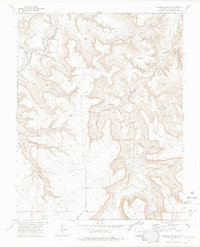
1972 Map of Johnson Canyon
USGS Topo · Published 1975About this map
Purgatoire River meanders through the northwest corner of this Colorado landscape, carving deep drainage systems into the high plains during the early 1970s. The terrain is defined by an intricate network of named canyons, such as Chacuaco Canyon, Seven Pocket Canyon, and Sandoval Canyon. Human presence in this arid environment is clearly marked by ranching infrastructure and water management, including the Garfield Windmill, Lower Windmill, and Upper Windmill. Genealogists may find interest in the Johnson Cem, while the existence of a Landing Strip and various Jeep Trails indicates the modern accessibility required for these remote cattle operations. The map records a specific era of Western land use where spring-fed locations like Barriet Spring and Jones Spring remained vital landmarks for local navigation and livestock survival.
Find a feature on this map
35 named features on this map. Tap any name to fly to it.
Don’t see what you’re looking for? This feature index may not catch every label — zoom into the map to look around manually.
Map Details
Editions of this 1972 Johnson Canyon Map
4 editions found
Other maps of this area

1891 · Timpas
USGS Topo · 1:125,000

1891 · Mesa De Maya
USGS Topo · 1:125,000

1893 · Mesa de Maya
USGS Topo · 1:125,000

1894 · Timpas
USGS Topo · 1:125,000

1955 · La Junta
USGS Topo · 1:250,000

1958 · La Junta
USGS Topo · 1:250,000

1968 · La Junta
USGS Topo · 1:250,000

1972 · Johnson Canyon
USGS Topo · 1:24,000

1972 · Doss Canyon North
USGS Topo · 1:24,000

1972 · Plum Canyon
USGS Topo · 1:24,000