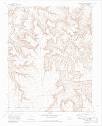
1972 Map of Johnson Canyon
USGS Topo · Published 1985About this map
Johnson Cem and a remote Landing Strip highlight this 1970s topographical record of the canyonlands in Las Animas County. The landscape is deeply carved by the Purgatoire River and Chacuaco Creek, which define the complex network of side canyons like Bruno Canyon and Johnson Canyon. This map documents a ranching infrastructure reliant on scattered water sources, including the Garfield Windmill, Round Corral Windmill, and several named springs such as Sandoval Spring and Barriet Spring.
Find a feature on this map
36 named features on this map. Tap any name to fly to it.
Don’t see what you’re looking for? This feature index may not catch every label — zoom into the map to look around manually.
Map Details
Editions of this 1972 Johnson Canyon Map
4 editions found
Other maps of this area

1891 · Timpas
USGS Topo · 1:125,000

1891 · Mesa De Maya
USGS Topo · 1:125,000

1893 · Mesa de Maya
USGS Topo · 1:125,000

1894 · Timpas
USGS Topo · 1:125,000

1955 · La Junta
USGS Topo · 1:250,000

1958 · La Junta
USGS Topo · 1:250,000

1968 · La Junta
USGS Topo · 1:250,000

1972 · Johnson Canyon
USGS Topo · 1:24,000

1972 · Doss Canyon North
USGS Topo · 1:24,000

1972 · Plum Canyon
USGS Topo · 1:24,000