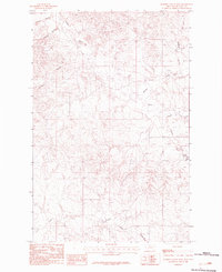
1983 Map of Johnson Coulee West
USGS Topo · Published 1983About this map
Nelson Creek and its complex network of drainage channels define this McCone County landscape in the early 1980s. This provisional survey captures the intricate topography of eastern Montana, where water has carved deep paths through the high plains. The drainage patterns of Morris Coulee and Dogtown Coulee in the northwest give way to the larger systems of Johnson Coulee and the South Fork of the Nelson Creek basin.
Find a feature on this map
8 named features on this map. Tap any name to fly to it.
Don’t see what you’re looking for? This feature index may not catch every label — zoom into the map to look around manually.
Map Details
Editions of this 1983 Johnson Coulee West Map
This is the sole edition of this map. No revisions or reprints were ever made.
Other maps of this area

1954 · Jordan
USGS Topo · 1:250,000

1954 · Glendive
USGS Topo · 1:250,000

1956 · Jordan
USGS Topo · 1:250,000

1957 · Glendive
USGS Topo · 1:250,000

1958 · Jordan
USGS Topo · 1:250,000

1958 · Glendive
USGS Topo · 1:250,000

1964 · Jordan
USGS Topo · 1:250,000

1973 · Rodgers Hall
USGS Topo · 1:24,000

1973 · Nelson Creek Bay
USGS Topo · 1:24,000

1978 · Fort Peck Lake East
USGS Topo · 1:100,000