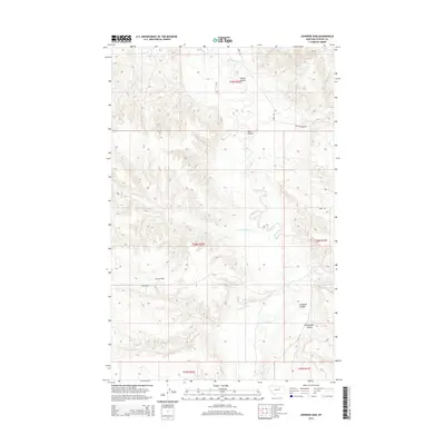
2014 Map of Johnson Dam
USGS Topo · Published 2014About this map
Beaver Cr and its tributaries carve a network of drainages across this Phillips County landscape, characterized by the distinct coulees that define the local topography. The namesake Johnson Dam sits at the center of the sheet, served by Johnson Rd and providing a focal point for water management in this cattle-ranching region. Further east, the terrain is marked by Guston Coulee, Moss Coulee, and the curiously named Pickhandle Coulee, which all flow toward the primary creek beds. The drainage patterns of Sevenmile Cr and Cottonwood Cr illustrate the arid-land hydrology where seasonal flows have shaped the earth over millennia. Local transportation is limited to established tracks like Harb Rd and the Ohs Cutacross Rd, highlighting the sparse settlement and expansive open-range nature of the Montana prairie in the early twenty-first century.
Find a feature on this map
16 named features on this map. Tap any name to fly to it.
Don’t see what you’re looking for? This feature index may not catch every label — zoom into the map to look around manually.
Map Details
Editions of this 2014 Johnson Dam Map
This is the sole edition of this map. No revisions or reprints were ever made.
Other maps of this area

1905 · Bowdoin
USGS Topo · 1:62,500

1954 · Glasgow
USGS Topo · 1:250,000

1957 · Glasgow
USGS Topo · 1:250,000

1958 · Glasgow
USGS Topo · 1:250,000

1984 · Clanton Coulee
USGS Topo · 1:24,000

1984 · Pinks
USGS Topo · 1:24,000

1984 · Harb
USGS Topo · 1:24,000
1984 · Harb SW
USGS Topo · 1:24,000
1984 · Horse Pasture Coulee
USGS Topo · 1:24,000
1984 · Content NW
USGS Topo · 1:24,000