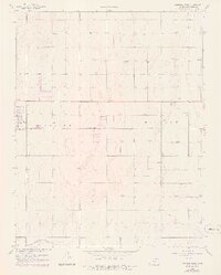
1959 Map of Johnson East
USGS Topo · Published 1978About this map
Johnson (Johnson City) anchors the western edge of this High Plains landscape, serving as a vital hub for the surrounding agricultural and energy-producing region. The Atchison Topeka and Santa Fe railroad line cuts directly across the center of the sheet, illustrating the critical role of rail transport in moving local commodities to market. This survey from the late 1950s, with later photographic revisions, reveals an extensive network of Gas Wells dotting the terrain, particularly in the northern and eastern sections. Infrastructure like the Stanton County Municipal Airport and the Sewage Disposal plant near the city limits reflects mid-century civic development. In the southern reaches, the drainage of Sand Arroyo Creek meanders across the flatlands, providing a natural contrast to the grid-like precision of section lines and transport routes.
Find a feature on this map
10 named features on this map. Tap any name to fly to it.
Don’t see what you’re looking for? This feature index may not catch every label — zoom into the map to look around manually.
Map Details
Editions of this 1959 Johnson East Map
3 editions found
Other maps of this area

1900 · Syracuse
USGS Topo · 1:125,000

1920 · Syracuse
USGS Topo · 1:125,000

1955 · Dodge City
USGS Topo · 1:250,000

1958 · Dodge City
USGS Topo · 1:250,000

1959 · Dodge City
USGS Topo · 1:250,000

1959 · Big Bow NE
USGS Topo · 1:24,000

1959 · Big Bow NW
USGS Topo · 1:24,000

1959 · Big Bow SW
USGS Topo · 1:24,000
1959 · Big Bow
USGS Topo · 1:24,000

1973 · Shore Airport
USGS Topo · 1:24,000