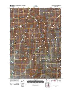
2011 Map of Johnson Heights
USGS Topo · Published 2011About this map
Johnson Heights serves as a central point of reference in this Wheeler County landscape, which is defined by a dense network of watercourses and topographical landmarks. The terrain is dominated by Steamboat Mountain and the sheltered lowlands of Indian Hollow and Smith Hollow. Water drainage patterns are clearly defined by the many winding tributaries, including Hardscrabble Creek, Tamarack Creek, and the playfully named Hide and Seek Creek. Transportation in this area is sparse, primarily centered on Parrish Creek Rd, which follows the path of Parrish Creek through the valley. This 2011 survey records a remote part of Oregon where natural features and family-named landmarks provide the primary structure for the region's geography.
Find a feature on this map
17 named features on this map. Tap any name to fly to it.
Don’t see what you’re looking for? This feature index may not catch every label — zoom into the map to look around manually.
Map Details
Editions of this 2011 Johnson Heights Map
This is the sole edition of this map. No revisions or reprints were ever made.
Other maps of this area

1953 · Richmond
USGS Topo · 1:62,500

1953 · Kimberly
USGS Topo · 1:62,500

1953 · Picture
USGS Topo · 1:62,500

1953 · Spray
USGS Topo · 1:62,500

1955 · Canyon City
USGS Topo · 1:250,000

1959 · Canyon City
USGS Topo · 1:250,000

1980 · Monument
USGS Topo · 1:100,000
1990 · Tubb Spring
USGS Topo · 1:24,000
1990 · Picture Gorge West
USGS Topo · 1:24,000
1990 · Frog Hollow
USGS Topo · 1:24,000